Thank you to all our 2015 runners. We’ve worked hard to make the course even better for 2016!
Rim To Rim Trail Run Course Maps
Half Marathon | Marathon | 50k | 50 Mile
We received a lot of great feedback about the race last year, and have made some modifications to the course that will remove some of the confusing course sections and make for an even better race experience. We’ll also have extensive course marking and monitors so runners can focus on racing their best on this challenging course. If you have any course questions, we’re available on Facebook or at [email protected].
The map below shows the trails used by all four race distances (half marathon, marathon, 50k, and 50 mile). See below for GPS tracks and elevation profiles.
For information on all the trails of the park, the city of Chico provides a detailed online Bidwell Park map, and a printable map of the Upper Park trails.
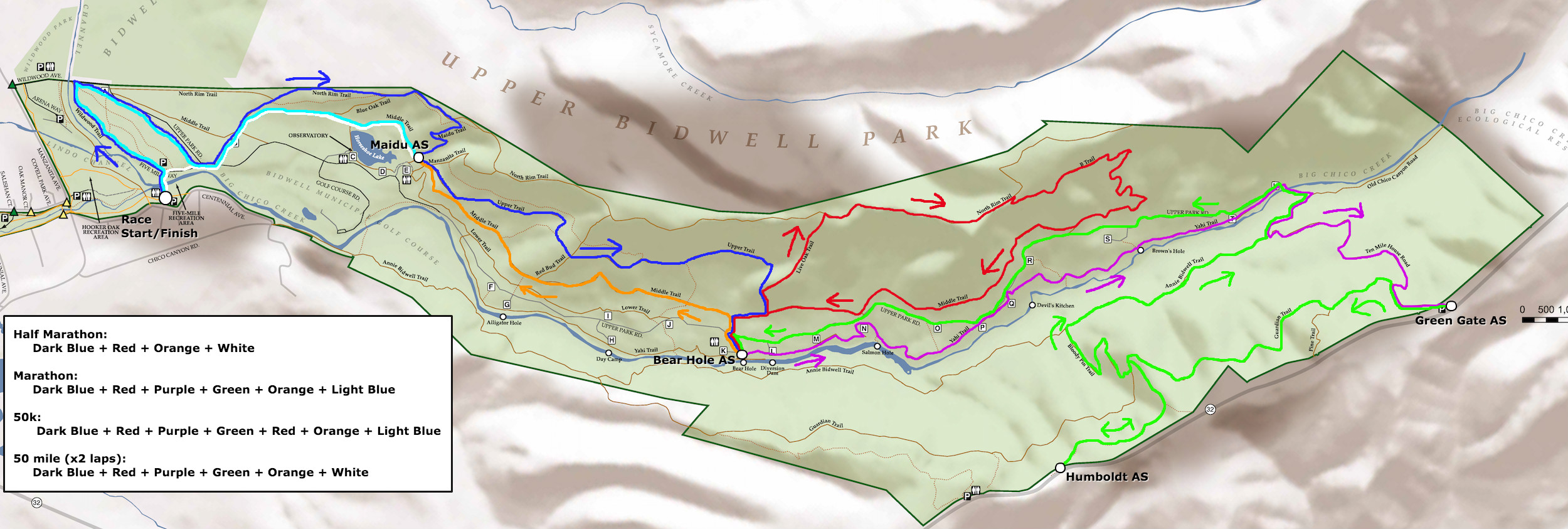
Click for a larger version of the course map. The legend lists the course segments run for each of the four race distances.
Half Marathon
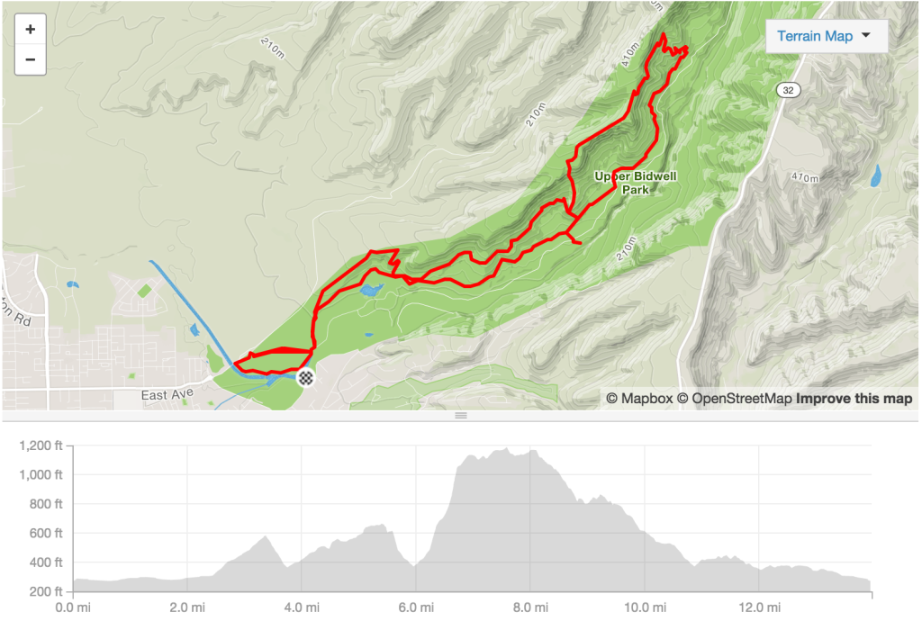
The 2016 Rim To Rim Trail Run Half Marathon Course and Elevation profile (click to see the route on Strava)
or click to see the route on MapMyRun. Total elevation gain for the half marathon course is approximately 2000′.
For anyone who would like the raw course files, they are available for download:
Marathon
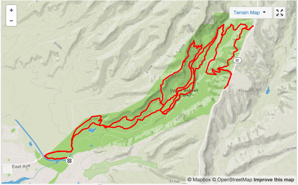
The 2016 Rim To Rim Trail Run Marathon Course and Elevation profile (click to see the route on Strava)
or click to see the route on MapMyRun. Total elevation gain for the marathon course is approximately 4200′.
For anyone who would like the raw course files, they are available for download:
50k
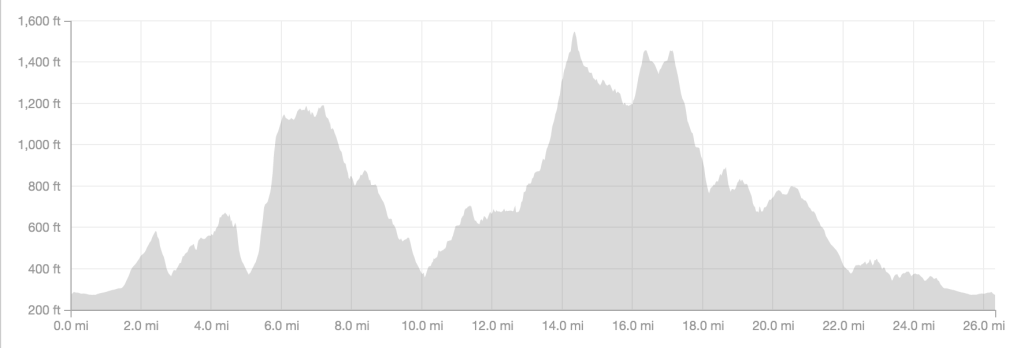
All 50k runners will follow the marathon course (see above). Upon returning to the Bear Hole Aid Station at mile 22, you will then run the North Rim Loop a second time (see mile 5 to mile 10 on the course profile). After the completion of this loop, you will again follow the marathon course to the finish line. This adds around 1000′ of additional elevation gain, for a total of approximately 5200′.
50 Mile
All 50 mile runners will follow the marathon course (see above), but will cut off the final mile on the return to the Start/Finish area. This will make a 25 mile lap, which will be run two times to reach the 50 mile total. Total elevation gain for the 50 mile course is approximately 8400′.
Thank you to all our 2015 runners. We’ve worked hard to make the course even better for 2016!
In addition to the start/finish area at Five Mile Recreation Area, there are four aid stations on the course: Maidu, Bear Hole, Green Gate, and Humboldt. Runners will pass through these aid stations anywhere from one to six times, depending on their event distance.
Start/Finish Area is located at the Five Mile Recreation Area on Centennial Ave. Friends, family, and crew are welcome here all day. Parking is limited, and additional parking can be found along Centennial Ave. as well as at Hooker Oak Park. There will also be space allocated for drop bags.
Maidu Aid Station is located at the trail junction of the Maidu Trail and Middle Trail. There will not be space available for crew, nor will there be drop bags.
Bear Hole Aid Station is located in Parking Area K on Upper Park Road. This location will have crew access available.
Green Gate Aid Station is located at the intersection of 10 Mile House Road and California State Highway 32. This location will have drop bags and crew access available for marathon and 50 mile runners. Drivers: Please be alert to highway traffic when entering or leaving the parking lot.
Humboldt Aid Station is located at a turnoff on California State Highway 32. There will not be space available for crew, nor will there be drop bags.
Please see the tables below for aid station mileage for each event.
Half Marathon
| Aid Station | Total Distance | Next Aid Station |
|---|---|---|
| 5-Mile Rec Area (Start) | 0.0 | 2.8 |
| Maidu (#1) | 2.8 | 2.2 |
| Bear Hole (#1) | 5.0 | 4.9 |
| Bear Hole (#2) | 9.9 | 1.7 |
| Maidu (#2) | 11.6 | 1.5 |
| 5-Mile Rec Area (Finish) | 13.1 |
Marathon
| Aid Station | Distance | Next Aid Station | Crew | Drop Bags |
|---|---|---|---|---|
| 5-Mile Rec Area (Start) | 0.0 | 2.8 | yes | yes |
| Maidu (#1) | 2.8 | 2.2 | no | no |
| Bear Hole (#1) | 5.0 | 4.9 | yes | no |
| Bear Hole (#2) | 9.9 | 4.4 | yes | no |
| Green Gate | 14.3 | 2.4 | yes | yes |
| Humboldt | 16.7 | 5.4 | no | no |
| Bear Hole (#3) | 22.1 | 1.7 | yes | no |
| Maidu (#2) | 23.8 | 2.4 | no | no |
| 5-Mile Rec Area (Finish) | 26.2 | yes | yes |
50k
| Aid Station | Distance | Next Aid Station | Crew | Drop Bags |
|---|---|---|---|---|
| 5-Mile Rec Area (Start) | 0.0 | 2.8 | yes | yes |
| Maidu (#1) | 2.8 | 2.2 | no | no |
| Bear Hole (#1) | 5.0 | 4.9 | yes | no |
| Bear Hole (#2) | 9.9 | 4.4 | yes | no |
| Green Gate | 14.3 | 2.4 | yes | yes |
| Humboldt | 16.7 | 5.4 | no | no |
| Bear Hole (#3) | 22.1 | 4.9 | yes | no |
| Bear Hole (#4) | 27.0 | 1.7 | yes | no |
| Maidu (#2) | 28.7 | 2.4 | no | no |
| 5-Mile Rec Area (Finish) | 31.1 | yes | yes |
50 Mile
| Aid Station | Distance | Next Aid Station | Crew | Drop Bags | Cut-off Time |
|---|---|---|---|---|---|
| 5-Mile Rec Area (Start) | 0.0 | 2.8 | yes | yes | (Race start @ 6:00 am) |
| Maidu (#1) | 2.8 | 2.2 | no | no | |
| Bear Hole (#1) | 5.0 | 4.9 | yes | no | |
| Bear Hole (#2) | 9.9 | 4.4 | yes | no | |
| Green Gate (#1) | 14.3 | 2.4 | yes | yes | |
| Humboldt (#1) | 16.7 | 5.4 | no | no | |
| Bear Hole (#3) | 22.1 | 1.7 | yes | no | |
| Maidu (#2) | 23.8 | 1.5 | no | no | |
| 5-Mile Rec Area (Lap 1) | 25.3 | 2.8 | yes | yes | 1:00 pm |
| Maidu (#3) | 28.1 | 2.2 | no | no | |
| Bear Hole (#4) | 30.3 | 4.9 | yes | no | |
| Bear Hole (#5) | 35.2 | 4.4 | yes | no | |
| Green Gate (#2) | 39.6 | 2.4 | yes | yes | 5:00 pm |
| Humboldt (#2) | 42.0 | 5.4 | no | no | |
| Bear Hole (#6) | 47.4 | 1.7 | yes | no | |
| Maidu (#4) | 49.1 | 1.5 | no | no | |
| 5-Mile Rec Area (Finish) | 50.6 | yes | yes | 8:00 pm |
Thank you to all our 2015 runners. We’ve worked hard to make the course even better for 2016!
Rim To Rim Trail Run Course Description
Starting at the Five Mile Recreation Area in Chico, California, the Rim To Rim Trail Run course covers the majority of the trails in Upper Bidwell Park. Big Chico Creek cuts a canyon through the low elevation Sierra Nevada foothills, and the canyon rims will treat runners to beautiful views of the creek, the canyon, and the Central Sacramento Valley.
All distances start and finish at Five Mile Recreation Area on the shore of Big Chico Creek. In addition to the start/finish area, there are four aid stations (AS) along the course. See below for a detailed description of each section between aid stations. The sections run for each race distance are also listed below.
Course Section Descriptions
Start to Maidu AS
From the start, runners will cross the bridge over Big Chico Creek and head left, making a flat loop around Wildwood Trail and running parallel to Upper Park Road briefly before crossing the road and heading up the gently sloping, but rocky, start of the North Rim Trail. After a brief climb, runners will leave North Rim Trail and turn right, descending Maidu Trail to join Middle Trail and arrive at Maidu Aid Station.
Maidu AS to Bear Hole AS
Leaving Maidu Aid Station, runners will continue very briefly on Middle Trail before veering left to take Upper Trail. Watch your footing here; Upper Trail requires your full attention! A steady climb and a short, steep descent on Upper Trail ends, and runners rejoins Middle Trail at a “T” intersection. A right turn will lead the ¼ mile down toward the Bear Hole Aid Station. (This area will have plenty of signs and a course monitor to eliminate any potential confusion.)
Bear Hole AS to Bear Hole AS via Live Oak Loop
Everyone should fuel up well at Bear Hole Aid Station, because the next section is a challenging five-mile loop. Leaving Bear Hole, runners will return to the intersection of Upper and Middle Trails, but branch off Upper Trail to the very steep climb up Live Oak Trail to North Rim Trail. This is easily the toughest ½ mile of the run. The climb continues along North Rim Trail (far more gradually) until the intersection with B Trail. A long, winding, singletrack descent to the end of B Trail will put runners back on Middle Trail. Continuing on Middle Trail will return runners to the Bear Hole Aid Station, completing the loop.
Bear Hole AS to Green Gate AS (Marathon, 50k, & 50 mi only)
From Bear Hole, runners will take the Yahi Trail, following Big Chico Creek upstream. The first mile of the trail is less frequently traveled and not as well-worn, so keep an eye out for the trail markers. The remainder of the trail is easy-to-follow single track which eventually ends at the termination of Upper Park Road. A short connector trail leads down to the edge of Big Chico Creek, where runners will get their feet wet and then climb another short connector trail up to 10 Mile House Road. This is a “road” in name only. It’s really an old, unmaintained Jeep road, and it climbs, steeply, from the creek all the way up to the canyon rim and Green Gate Aid Station.
Green Gate AS to Humboldt AS (Marathon, 50k, & 50 mi only)
Leaving Green Gate, runners will descend briefly down 10 Mile House Road before turning left onto Guardian Trail. This rolling singletrack will give you gorgeous views as you slowly descend before making a sharp left onto Humboldt Trail. A short climb up will lead back up to Highway 32 and the canyon rim, where you will find the Humboldt Aid Station.
Humboldt AS to Bear Hole AS (Marathon, 50k, & 50 mi only)
Returning down Humboldt Trail from the Humboldt AS, runners will intersect with Guardian Trail, making a left followed immediately by a right turn onto Bloody Pin Trail. This is a short, steep descent with several hairpin curves, eventually ending at a “T” with the Annie Bidwell Trail. A right turn will follow the gently rolling singletrack until it too ends at a junction with 10 Mile House Road, and the short descent back to Big Chico Creek. Crossing the creek, runners will this time stay on Upper Park Road. This section of Upper Park Road is closed to traffic and unmaintained dirt and gravel, so while it’s wide and not particularly steep, continue to watch your step. Upper Park Road will parallel Big Chico Creek as you head downstream, eventually reaching Bear Hole Aid Station once again.
Bear Hole AS to Maidu AS & Maidu AS to Finish
Leaving Bear Hole Aid Station, runners will head down Middle Trail and once again pass through Maidu Aid Station. Continuing on Middle Trail to the parking lot and trailhead, runners will cross Upper Park Road, then parallel the road and reverse their loop around Wildwood Trail until they reach the bridge at Five Mile Recreation Area.
Course Sections by Race Distance
Half Marathon
- Start to Maidu AS
- Maidu AS to Bear Hole AS
- Bear Hole AS to Bear Hole AS via Live Oak Loop
- Bear Hole AS to Maidu AS
- Maidu AS to Finish
Marathon
- Start to Maidu AS
- Maidu AS to Bear Hole AS
- Bear Hole AS to Bear Hole AS via Live Oak Loop
- Bear Hole AS to Green Gate AS
- Green Gate AS to Humboldt AS
- Humboldt AS to Bear Hole AS
- Bear Hole AS to Maidu AS
- Maidu AS to Finish
50k
- Start to Maidu AS
- Maidu AS to Bear Hole AS
- Bear Hole AS to Bear Hole AS via Live Oak Loop
- Bear Hole AS to Green Gate AS
- Green Gate AS to Humboldt AS
- Humboldt AS to Bear Hole AS
- Bear Hole AS to Bear Hole AS via Live Oak Loop
- Bear Hole AS to Maidu AS
- Maidu AS to Finish
50k runners will run the marathon course, with the addition of a second running of the Live Oak Loop.
50 Mile
- Start to Maidu AS
- Maidu AS to Bear Hole AS
- Bear Hole AS to Bear Hole AS via Live Oak Loop
- Bear Hole AS to Humboldt AS
- Humboldt AS to Green Gate AS
- Green Gate AS to Bear Hole AS
- Bear Hole AS to Maidu AS
- Maidu AS to Finish
The 50 mile course consists of two identical laps of the above course.